Find a Commercial Property on 4Propsearching thousands of offices, retail, industrial,
Investments, land, developments, farms, welfare and leisure properties for sale or to let.
Development - Residential for Sale
Poultney Lane, Kimcote, Lutterworth, LE17
Development - Residential for Sale
Poultney Lane, Kimcote, Lutterworth, LE17
At the front of the site is the 3-storey Grade II Listed farmhouse which is of traditional solid brick construction under a pitched slate roof extending to 395.49 sq.m. (4,257 sq ft). Floor plans suggest that the property is a substantial 4-bedroom house with kitchen, living quarters and lounge with storage accommodation at second floor level which could be adapted to provide additional living space.
In addition to the farmhouse, are 3no. barns / outbuildings of various forms of construction. There is a former feed store comprising a single storey building of solid brick construction under a pitched slate roof extending to 320.76 sq.m. (3,452 sq ft) and a more basic barn style building extending to 1,126.91 sq.m. (12,130 sq ft).
To the east of the buildings are 2no. fields which are separated by a pond. The site starts to narrow away from Poultney Lane. It is understood that the rear field lies within Flood Risk Zone 3. The site is designated as Grade 3 agricultural land.
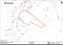
Location
Kimcote is a village and Civil Parish situated in the Harborough District of Leicestershire, approximatey 4 miles northeast of Lutterworth. The village has a populaton of just 605 (ONS 2021 Census). The site is located on Poultney Lane in the centre of the village and is bounded by residential properties to the north and south, Poultney Lane to the west and fields to the east. The River Swift runs along the bottom of the site just outside of the boundary. Access to the site is from Poultney Lane.Amenities
Former FarmlandResidential Development Opportunity (Subject to Planning)
Attractive village location
Substantial Grade II Listed farmhouse